Search This Blog

Friday, March 18, 2016

Massacoe State Forest - Great Pond Block


If you're looking for a peaceful walk surrounded by beauty, this is it. No hiking equipment is necessary to enjoy the lush environs at Great Pond. I love the hush of entering the forest on a path carpeted with pine needles, and after the barrenness of winter, the new growth surrounding us was a welcome sight.
Giant white pines tower over the younger trees that fringe this trail.

This pathway lined with rhododendrons promises to be stunning when in bloom, and the mountain laurel was abundant.

We took a right turn to walk by the pond, then headed south and did two loops through the woods, returning us to the pond.
A popular site for bird watchers. In the summer, blooming water lilies will be plentiful.

At this point we needed to make a decision. We could take the trail south, cross the street and explore Wagner Woods, but rain was in the forecast. I don't mind getting wet when it's 80 degrees, but wet weather in the 40s is a different story. As we were discussing our options, one little drop of rain landed on my forehead, and we decided to head back to our cars and have our devotional time.
Isaiah 55:9
“As the heavens are higher than the earth, so are my ways higher than your ways and my thoughts than your thoughts.” 
When hiking at a high altitude, I glanced down and noticed the small speck of a car moving down a pencil-thin highway. But the highway was blocked at a bend in the road by a fallen tree. They couldn’t see it, but I could. I could have helped them find a detour around the trouble if only they would look up and follow my directions. 

This birds-eye view of our lives is exactly the view God has. He can see the whole of our lives, knows where we are in our journey, and He knows precisely where we need to go. We can’t see where our trails and trials will ultimately lead, nor can we see all the dangers that await us or the detours that will help us skirt those dangers. All we can do is keep our eyes and hearts on God, and wait for His guidance.

It’s comforting to know that God sees the whole of my life. His ways are higher than our ways, His thoughts higher than our thoughts. If we will trust in Him we can rejoice, even in the darkest hour, knowing that He has a plan and a purpose for our lives. (Adapted from "With God on the Hiking Trail" by Nathan Chapman.)
At the closing of the devotional, the raindrops started splotching here and there, and on the drive home the rain was falling. I was glad I heeded that one little drop of warning, and it made me smile to think of how it interlaced with our devotional. Sometimes we're tempted to ignore the signs warning us that we're on the wrong path. We want to barge ahead with our own plans without spending time in prayer and heeding wise counsel. Life doesn't always go as we planned, but we can trust God with the assurance that His ways are higher than ours, that He has a plan and a purpose and, as Romans 8:28 tells us, all things work together for good to them that love God.

Our route can be viewed in detail at: https://runkeeper.com/user/ValleyHikers/activity/753643453?tripIdBase36=cgp70d&activityList=false&
Address: Great Pond Road, Simsbury (east of Linda Lane on the north side of the road)
Trail map: http://www.ct.gov/deep/lib/deep/stateparks/maps/massacoe.pdf
Length: 2.75 miles
Duration: 1 hour, 12 minutes
Calories burned: 243
Difficulty level: easy


Saturday, March 12, 2016

Godard Preserve & Mary Edwards Mountain

Not only was Alice Godard generous enough to donate 107 acres of land to the Granby Land Trust, she also created an endowment for the construction and maintenance of trails. In addition, her daughter Barbara donated a five-acre parcel. Mary Edwards donated 250 acres of her land and was a major supporter of the GLT. We were privileged to reap the benefits of their generosity on this beautiful day.

The well-marked blue-blazed trail took us downhill to a stream, and we commented on how calming it is to hear the gentle rush of the water spilling over the rocks.


The trail took us by the water for a little while and then veered east. 


We turned left taking the yellow trail around and then back onto blue, crossing the stream on the south side, bringing us back to blue and uphill to our starting point. We'd been out about an hour and had walked a little over a mile and a half.


We then crossed Donahue Road and entered the trail to the Mary Edwards Mountain property. This is an uphill climb (but not steep) for about four-tenths of a mile. It took us a little less than 20 minutes to reach Mary's Rock, where the endless view includes Springfield, Mass and the Mount Tom range. This view can easily be reached by parking on the side of the road in the pullout provided on Mountain Road, just west of Silkey Road.


We paused there for for our devotional:
Proverbs 3:6 "In all your ways submit to Him and He will make your paths straight." 
Most great hikes of history take the same route - a big circle. When people travel to Nepal to climb Everest, they leave from the same airport at which they arrived three months earlier. So why go to all the trouble? How about a sunset glow at 6000 feet? The beauty of the glow of the horizon is doubled as you remember each step taken to reach the scene.  Hiking involves circles, and so does life. Solomon commented on this when he wrote, "All of it is meaningless" (Ecclesiastes 2:17). While the circle itself may be meaningless, the effect the journey has an us. is not. 
But what about our spiritual journey? As we press forward in our spiritual walk, we have a destination. Heaven is our home. Rather than circular, this path is straight and narrow. We have a direct path to eternity. Everything is circles in our earthly lives except our spiritual journey, which leads us to our eternal destination. Let's trust in Him on our lives' straight and narrow paths.- adapted from "With God on the Hiking Trial"by Nathan Chapman.

I had underestimated the length of time it would take us to reach this point. Since I promised the hike would be under two hours, we decided to take a shortcut and go counter clockwise on the yellow trail, which took us by (and under) some interesting trees.

Someday we will have to return and explore the rest of the trails. Preferably in the fall, when I imagine the view will be breathtaking.

Our Route - view map and stats in detail: https://runkeeper.com/user/ValleyHikers/activity/748854777?tripIdBase36=cduk1l&activityList=false&
(requires runkeeper account)

Address: Donahue Road, Granby ( about a half mile down on the east side - there is a sign, and parking is available on the side of the road)
http://www.granbylandtrust.org/Trail%20Guide%20Sign-4.pdf
Length: 2.8 miles
Duration: 1 hour, 50 minutes
Calories burned: 444
Difficulty level: easy to moderate
Climbs:


Saturday, March 5, 2016

Northwest Park

Soon after my morning coffee I received a text, “Good morning Sue, too cold for me today, sorry. Have a good time." And then a second cancellation through a phone call, “It’s frigid - the wind chill is 15!” I began to have my doubts, and the sofa and a second cup of coffee started to sound tempting. I texted Linda J - do you think it’s too cold? Her response was, “We know how to dress.” So I reluctantly layered up and got in my car, figuring my previously planned route of four miles might be cut short due to shivering.

Four of us were ready to explore Northwest Park in Windsor, and it turned out to be a lovely day and a lovely place.  We stopped in the Nature Center to visit the clean, up-to-date restrooms. There are many trails at the park - 12 miles worth. I showed two employees the route I had mapped out, and they suggested we add a side trip to the beaver pond. So instead of cutting it short, our four-mile route became almost five miles! We did a little bit of wandering, as we weren’t quite sure we were going in the right direction, turned around, and then had to backtrack. No beavers were out and about, but we did see evidence of their presence, and it was a pretty trail.


When then headed north on the yellow-blazed trail which meandered by the Farmington River. It was at this point that two of us were peeling our jackets because we were getting too warm. The sun was shining, the wind had died down, and although it was hovering around 30 degrees, the weather felt balmy.

One of our members, Cheryl J, had just returned from a medical missionary trip to Jordan, and we were privileged to hear about her experiences while ministering to Syrian refugees as we continued onto the pink-blazed Rainbow Reservoir trail.


After enjoying a nice view of the reservoir, we made our way back via the Open Forest, Softwood Forest, and Wetland Forest Trails which brought us back to the Nature Center. 


Upon our return, the park was bustling with activity, and the sweet scent of wood smoke and maple syrup was in the air. Children were enjoying the playground and the animal barn with it’s donkey, rabbits, sheep, and turkeys.


We made a brief stop in the maple sugar house where the process of sugaring was being explained and the sap boiled nearby.

The facilities are well maintained and offer a wide variety of activities - everything from pancake breakfasts to concerts to outdoor camps. Be sure to visit northwestpark.org for a list of events. We were very impressed!

Our route.  View map and stats in detail at
https://runkeeper.com/user/ValleyHikers/activity/744906489?tripIdBase36=cbhxix&activityList=false&
(requires free runkeeper account)

Address: 145 Lang Road, Windsor
Trail Map: http://www.northwestpark.org/pdf/New_NWP_Map.pdf
Length: 4.8 miles
Duration: 2 hours, 37 minutes
Calories burned: 652
Difficulty level: moderate
Climbs:


Friday, January 15, 2016

Horse Guard State Park

Update 11/20/20: The trailhead has been moved a little north. Address has been corrected.

Words that show my ignorance of Connecticut terrain: "It's in the middle of the city, how hard can it be?" I misled our group of 12 into thinking this hike would be a piece of cake, and was surprised, a bit chagrined, and also delighted to find a difficult climb.

The trail is easy to spot and begins with well-marked white blazes. However, the blazes stop appearing about a half mile into the woods. Perhaps they end because it's wise to turn around at that point, and half of our group opted to do just that. The terrain was nothing but rock and required some scrambling.


When we made it to the top, there were six of us remaining, but there was quite a view!

We paused for our devotional, taken from James 2:17:

"In the same way, faith by itself, if it is not accompanied by action, is dead." The author (Nathan Chapman) tells of a story when he and his friend were camping at a shelter and a group nearby was having a rowdy time, consuming a lot of alcohol in the process. Alcohol consumption while in the backcountry is extremely dangerous due to inability to register true body temperature and hindering our sense of direction. They woke in the middle of the night to find that one of the men had wandered off. His buddy found him facedown in a stream where he had vomited and passed out. Hypothermia had set in and he was in danger of drowning. While other campers rushed to help, Mr. Chapman had very little compassion for the fellow who had given in to such irresponsible behavior, and didn't offer to help. Later, guilt set in. He writes, "I was guilty of being inebriated by self-righteousness. Of all the people who should've been willing to lift another fallen soul, I should have been the first. Not because I was better, but because Jesus taught his followers to reach out to others. . . The scripture says if we have faith we will act. It's easy to give assistance to those who need help because of a situation they had no control over. Helping those who find themselves in need because of poor judgment or different priorities challenges our compassion. But where would we be if others had that attitude when we needed mercy? Since that night on the trail, I no longer sit back when others need help, because it is extension of my faith in Christ." We all have made foolish choices. We need to be sensitive to others who need help along the way, even when they get themselves into trouble.

We then started making our way down, which proved to be a bit tricky


The point where the blazes stopped. After some deliberation on the way up, we chose to go left. On the way down we found that a better choice would have been to go to the right.
While our total time was 2 hours, we had a couple of long pauses during the hike, one while we tried to decide which way to go and another when we realized our group had gotten separated. It could probably be accomplished in an hour and a half or less. We agreed that it was a fun hike and we'd like to do it again. 

View Map and Stats at https://runkeeper.com/user/ValleyHikers/activity/691270960
(requires free runkeeper account)
Note the spike in the center - on our way back we took a wrong turn to the north because some of the trees had white paint that looked like blazes. One of our members with a keen sense of direction felt it wasn't right (yay Lisa!). A check of our trusty Runkeeper app showed us we were going the wrong way, so beware of false blazes.

Address: 245 West Avon Road, Avon CT
Length: 1.3 miles
Duration: 2 hours
Calories burned: 475
Difficulty level: moderate to difficult


Friday, November 13, 2015

Roaring Brook Nature Center

When you're browsing at the shopping mall in Canton with the busy traffic flying by on Route 44, it's hard to believe that a mere four minutes away is a tranquil setting in the woods with five miles of trails to explore.

Roaring Brook Nature Center is a wildlife center and outdoor classroom, with seasonal exhibits, gardens, educational programs and concerts. It would be fun to explore the area further, but our objective was a hike in the woods.


We began on Werner Pond Trail, crossing over Jim Brook Stream.


We continued on to the Quarry and Plantation Trails and came to a clearing where we could see Heublein Tower in the distance.


After completing Plantation Trail we turned right onto Orchard Trail and then took another right to rejoin Quarry Trail. This was prettiest trail yet, taking us along the southern section of Jim Brook Stream.

We then went on to the Dutch Mill Pond Trail which featured a lovely waterfall.


After returning to the parking lot, a couple of us decided to cross the road onto Ridge Trail. It was there that four deer went running through the woods. The buck stopped and watched us as we made our way across.


Our devotional today was based on 2 Corinthians 12:9: "But he said to me, 'My grace is sufficient for you, for my power is made perfect in weakness.'"

The writer tells of a time when his friend had made the mistake of wearing textured cotton socks the week before their hike, and he was paying for his poor decision with a nickel-sized blister. In spite of the pain, he didn't let his blunder keep him from the trail.

Many of us start our Christian journey with the blisters of poor decisions made before we met Christ. God doctors the blistered areas of our hearts with the salve of His forgiveness and covers our wounded hearts with His grace.  If there's friction between us and others have offended us, we are told to forgive them. God's Word directs us to take off the rough garments of envy, gossip, and other blister-producing material. Once removed, He places the robe of His righteousness around us. (Adapted from "With God on the Hiking Trail" by Nathan Chapman http://store.steveandanniechapman.com/products/with-god-on-the-hiking-trail.)

View Map and Stats at https://runkeeper.com/user/ValleyHikers/activity/691270960
(requires free runkeeper account)

Address: 70 Gracey Road, Canton, CT
Trail Map: http://www.roaringbrook.org/publications/trailmap.pdf
Length: 2.85 miles
Duration: 2 hours
Calories burned: 523
Difficulty level: easy/moderate


Saturday, November 7, 2015

Mica Ledges Trail

"Yea though I walk through the valley of death . . . " Okay, I'm exaggerating. While it wasn't actually a valley of death, we did have our concerns. Because I'm new to hiking, I'm constantly learning, and today I learned that wet leaves and steep descents make things a bit dicey!

We went west on the blue trail to make our way to Pyamid Rock, a large boulder that was displaced from the ridge by glaciers. It's hard to imagine anything could move a rock that size. The process is interesting, and is described at the end of this post.

After passing the rock the trail splits, with the blue Mattabesett trail continuing on and the orange trail turning to the left behind Pyramid Rock. We chose the orange trail, which gave us a nice climb. So far, so good. Then we came to a steep descent, which was a bit treacherous for us. I imagine the trail is easier when it isn't covered with leaves, but it is rather steep. We made our way down slipping and sliding.

While our total climb was not that steep, there were steep places along the way.


When we were one mile in, we came to a spot where we couldn't see a blaze, and we couldn't see the leaf-covered trail.
We wandered around in this area, unable to find a blaze.
Finally, one of our eagle-eyed women spied a far-off blaze. We were back on the trail! We continued on, making our way to the southern end, and stopped here to have our devotions. When I read the scripture, we all chuckled.  

Psalm 23:3-4 “He guides me in paths of righteousness for His name’s sake. Even though I walk through the valley of the shadow of death, I will fear no evil, for you are with me.” 
For ages, writers have documented moments of peace in nature, but few have followed the path of serenity into dark valleys like David did. Why did he trace the path of righteousness into the valley of death? The psalmist knew that even when we walk closely with God, sometimes the trails of this life lead into places filled with despair. But even in those situations David responded with a declaration of confident peace; “I will fear no evil.” 
Sometimes following the path of righteousness leads us to where we don’t want to go. Our ultimate goal is not to find the path of least resistance, but to follow the path of God. Good times and hard times on the hiking trail go hand in hand. And in the same way, both the bitter and sweet times in life are on the same path. Thankfully, we know where this trail ends: “And I will dwell in the house of the Lord forever (Psalm 23:6). (Adapted from "With God on the Hiking Trail by Nathan Chapman.)

We had just been through a valley. It most definitely was not a "valley of death" and we weren't even close to a state of despair, but it wasn't a piece of cake :)

We could have finished the loop at this point, but we decided to continue on to the next trail. We followed the orange blazes and came to an outcrop where the orange trail meets the blue Mattabesett. I went ahead and checked the trail to the left. There was no way I was going to do this trail, as there was a drop off. Then I went to the right. Same thing. Even on a clear dry path, this trail was not for me! So we turned around and made our way back. The orange trail took us by Whitney Pond, where we admired the tranquility.


After this the trail became easy. It was nice and flat and we were glad. Although the hike was only 2.5 miles, due to the precariousness, it felt longer. It was a gray, cloudy day, so the great views that were promised weren't visible. Perhaps this is a trail that's better suited to a clear, sunny, dry day. But, all in all, everyone had a good time. It's always good to walk in the woods and be surrounded by nature!


Directions: Cream Pot Road in Durham. Drive to the dead end. Keep going when it becomes one lane, parking is on the left.
Trail Map: http://www.madisonlandtrust.com/wp-content/uploads/2011/10/Mica-Ledges.pdf
Length: 2.5 mile
Duration: 2 hours, 20 minutes
Calories burned: 582
Difficulty Level: Difficult

A glacier moves rocks by "plucking." As a glacier moves over the landscape, water melts below the glacier and seeps into cracks within the underlying bedrock. This water freezes and melts, weakening the bonds holding pieces of bedrock in place. These pieces of rock can now be picked up or plucked from their rocky base and carried along with the moving glacier. If you ever put an ice cube on your finger and felt the skin on your finger stick to the ice cube, then you have a fairly good idea of how plucking works. 
http://study.com/academy/lesson/glacial-erosion-definition-processes-features.html

Friday, October 30, 2015

Macricostas Preserve

We were blessed to again experience a little physical and spiritual training in God's great outdoors, this time on Pinnacle Trail, part of the land trust owned by Steep Rock Association in New Preston. The hike begins in an lovely open meadow, so it was a plus that the air was chilly and we weren't subjected to a blazing sun.


Amidst a group of bald trees, a leafless tree with bright red berries caught our eye. Perhaps a hawthorne tree?


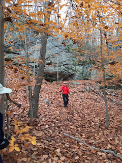
Although this week's heavy rain and wind sent many leaves flying off the trees, once we were in the woods, there was still plenty of color to be seen.


What a mood-booster to embark on a trail with golds, oranges, and reds in the foreground and the deep blue sky in the background!

A little over a mile in we came to the first lookout. We stood and admired the view as we watched the shadows from the clouds move across the valley.


After this, the climb became a bit more challenging with a lot of rocks. No scrambling was necessary, though, as we made our way up. Even with fallen leaves obscuring our path, the blazes were so well-marked we had no problems finding our way. A sign pointed us to the Pinnacle (known as Waramaug Rock), for which I was thankful, because the trail then becomes level, and I started having my doubts. But we continued on, went left at the fork and before long we were in the wide open, with that top-of-the-world exhilaration of a dramatic view.


We circled in front of some trees to block the wind and had our devotional time.
Mark 2:27 "The Sabbath was made for man, and not man for the Sabbath." When we're hiking, it's best to stop and rest along the way, rather than pushing ourselves until our bodies shut down. God has not designed us to always be on the go. He included in our humanity the need to rest. Ignoring that time of rest and pushing on can result in shallow relations with God and others, fatigue that breaks down the immune system, and an early trip to the grave.  If you’re racing through life, don’t forget the benefits of taking time to rest, and in that rest turn your attention to God. In this, our spirits and bodies are both renewed. (Adapted from With God on the Hiking Trail by Nathan Chapman).
We were blessed to have Cassidy Parent join us. Cassidy is a missionary with Kids Alive International and will be heading back to Haiti in January. We always enjoy her company and hearing about her adventures, and were privileged to lift her up in prayer.

We reluctantly left the mountaintop and made our way back down. The real world awaited with tasks to be accomplished, but for a few hours we experienced the delight of leaving our routines, drawing closer to God and each other, and marveling in the wonder of His creation.


Directions: Turn onto Christian Road from Route 202. Park behind the old red house on the north side of the road. The parking lot is easy to find and can be spotted from google earth at maps.google.com
Trail map: http://www.steeprockassoc.org/explore/macricostas-preserve/macricostas-preserve-trail-map/
Length: 3.4 miles (you also have the option of parking a second car on June road and making this hike a little shorter)
Duration: 2 hours, 30 minutes
Difficulty level: easy in the beginning, climb is moderate
Calories burned: 600